By Baluku Jack
Residents living in areas prone to disasters in Bundibugyo district are concerned of the rains that befell the Rwenzori Sub-Region in the Months of July and August.
Bundibugyo District is vulnerable to a number of hazards that lead frequently to disasters. They include flooding, landslides, drought, animal attacking crops, livestock and humans, crop pests and diseases, environmental degradation, internal conflicts, hailstorms, wind storms, bush fi res, human epidemic and earthquakes.
The District’s geographic center is located at 00˚ 43’N, 30˚ 04’E. The District is bordered by Hoima District to the northeast, Kibaale District to the East, Kabarole District to the South, and the Democratic Republic of the Congo to the West and North.
The most vulnerable communities in Bundibugyo District are Kasitu, with a weighted vulnerability of 5 (medium). Kasitu Sub-county is closely followed by Bubukwanga, kirumya, Nyahuka Town Council, Bukonzo, and Ngamba Sub-counties with weighted vulnerabilities of 4, 4, 3, 3, 3 (low) respectively.
The least vulnerable communities are those of Harugale, Sindila, Mirambi and Bubandi Sub-counties with a weighted vulnerability of 1 (low) each.

Now, as heavy rains are anticipated this season, the locals who have on several occasions been affected by a number of disasters that befall he district are living in fears as most of them are uncertain on how they can live with the befalling calamities.
On 19th august, 2019, flash floods hit the district, killing one person and subsequently destroyed properties in Ntandi town council. This happened after River Lamya bursts its banks
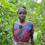
Vincent Kamalabe, 65, a resident of Nyakilo Village in Bundimulombi parish, says they have developed fears that since they are nearing the rain seasons, disasters might hit the district as it has been the case especially during the months of July and August.